Archaeoastronomy: reconnecting to reality. Part II

Archaeoastronomy: reconnecting to reality. Part I.
January 25, 2010
Science Day at ESO
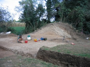
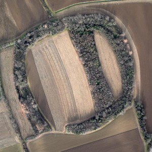
February 25, 2010As I discovered in the initial phases of the study, the issue about the orientation of these sites had been already raised by other researchers. The first written reports (in the ’40s of last century) were mentioning that they all had the vertexes aligned along the cardinal axes. The same conclusion was reported also in several archaeological studies. But, most important of all, a more astronomically-oriented analysis had been published in 1986 by Aveni and Romano on the Journal for the History of Astronomy. Anthony Aveni is one of the most famous researchers in Archaeoastronomy and he has written many papers and books on this subject. This was more than sufficient to stimulate my curiosity, besides being a clear challenge. The first step was to establish a contact with archaeologist Dr Susi Corazza, who is working at the Laboratory of Protohistory at the University of Udine. She gave me several reports of archaeological digs carried out in these sites in the last ten years and she also invited me to visit an open excavation in Galleriano, one of the three well preserved sites.
There I was exposed to a completely new way of doing research. I could walk over the embankment, watch the stratigraphic sections, have samples of earth in my hands, smell the freshly excavated soil… a contact to objects which is forbidden to astrophysicists. And, most important of all, having to do with human artifacts. The excavation campaign, supervised by Susi, was conducted by undergraduates, PhD students and post-docs, under the hot sun of August. I must say I felt several times overwhelmed by emotions.
Two of the sites had been surveyed from the ground by the University using a classical ground-based total station, while for the third (Savalons) nothing was available. For this one I had a different idea. In fact, there is now the possibility of getting a 3D mapping of a site using an airborne laser device. This is typically used for civil purposes, like topography and the like, bit it has been used also for archaeology.
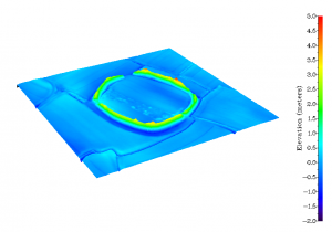
The concept is very simple. A laser beam is sent down, reflected by the soil and received back by the device, which is capable of measuring the time it takes the signal to come back, with extremely high accuracy. If you then know precisely where your device is, you can then reconstruct the elevation profile of any 3D structure, with centimeter accuracy. Easy, uh? Well, yes, but it requires some expensive equipment and an helicopter. This is why I contacted HELICA, a local company, which is specialized in this kind of work. “We have never done this before” – said to me Diego Plos, Helica’s Director – “so we’ll give it a try and see what comes out of it”. And, yes, they did it. In a matter of a few seconds the LIDAR (that is the name of the device) has collected about a million points, spaced by about 30 cm. Amazing! A ground based survey of these structures takes many days, to collect a thousand points at most. Not only, but based on the properties of the reflected light, during the post-processing phase one can distinguish between ground and false-ground data (produced for instance by foliage). The data are so good that you can see the signs of cultivations in the fields.
But most interesting of all, the geometry of the site (approximately 180m on a side) appears very clearly. Clearly, the orientation analysis with digital, geo-referenced data is just a matter of computer skills and the smell of the archaeological digs is already far away.To complete the analysis (terrain slope, horizon) I also made use of the Shuttle Radar Topography Mission, which is essentially based on the same principle and it uses a radar instead of a laser. With this, for instance, I can check whether a site has been aligned along the direction of maximum slope, something which was typical in the Roman centuriation to favor the draining of rain water. Or I can try to see whether the orientation was done along the direction to some remarkable structure on the natural horizon, like a far, high mountain peak.
In fact, in archaeoastronomy is rather easy to be carried away and see alignments everywhere. This is actually a bit of a plague in this field, and the enthusiasm brought about by the findings in Stonehenge and the like has created a generation of improvised researchers, who have not exactly followed scientific criteria in their studies. Therefore, more than a grain of salt is necessary. And this actually makes the whole thing attractive for a scientist. The analysis is almost over and I am now convinced that there is no alignment to astronomically significant directions in these proto-historical sites. Even the orientation to cardinal points, suggested by early investigations (and reported more by tradition than by measurement), does not hold. At this point you might wonder whether the disproval of previously reported “facts” is really useful. Well, yes, it is. Here in archaeo-astronomy as well as in astrophysics or in any other science, for that matter.
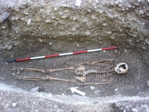
Meanwhile the archaeological digs have continued. Most remarkably, Susi and her collaborators have opened the mound close to Savalons, finding a human body deeply buried under it, which has now been dated around 1800 b.C. You can watch a movie about this finding here on YouTube.
If they’ll keep finding tombs like this (this is the 3rd one), we will be in the condition of starting an analysis about the orientation of proto-historical graves in the High Friulian Plain. This is another interesting topic connecting human life (well, actually human death) with astronomy. An example study can be found here.
In a subsequent post I will report a bit more in detail about the kind of analysis I have performed on the three sites.
This entry was posted on Friday, January 22nd, 2010 at 2:47 pm and is filed under Uncategorized. You can follow any responses to this entry through the RSS 2.0 feed. You can leave a response, or trackback from your own site. Edit this entry.
