Curiosity about sand dunes (part 2/2)

Curiosity about sand dunes (part 1/2)
December 14, 2015
That which curves and that which is straight
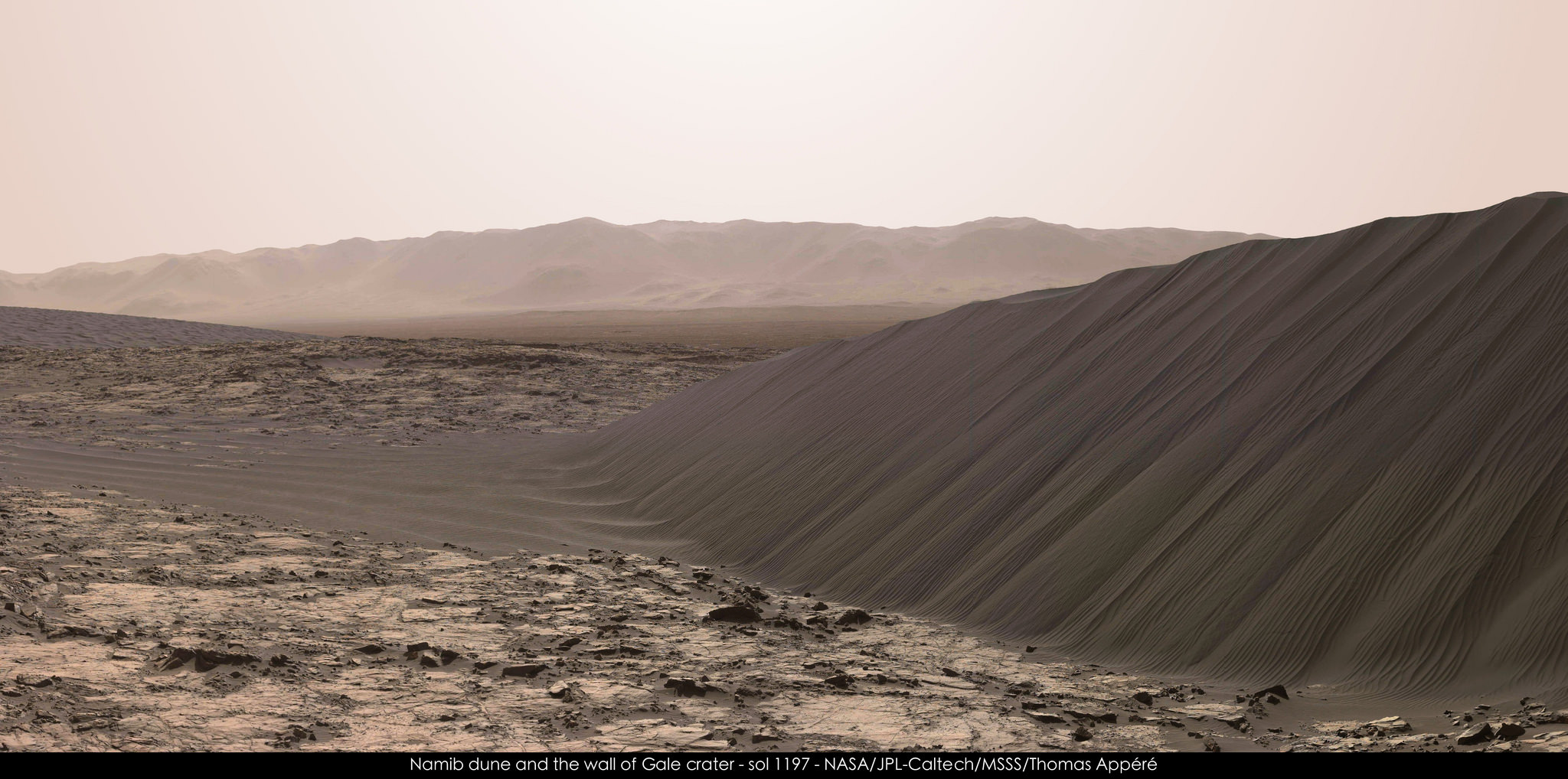
December 30, 2015Today is December 21, 2015 (northern winter and southern summer solstice on Earth). On Mars it is Ls = 84º, Mars Year 33 (about 12 sols from northern summer and southern winter solstice on Mars). It is sol 1200 of Curiosity’s mission on Mars, and the rover is working its way around the southern side of Namib Dune. Part 1 of my previous post shows part of the windward (northeastern) side of High Dune. This time I’ll show pictures of the slip face of Namib Dune.
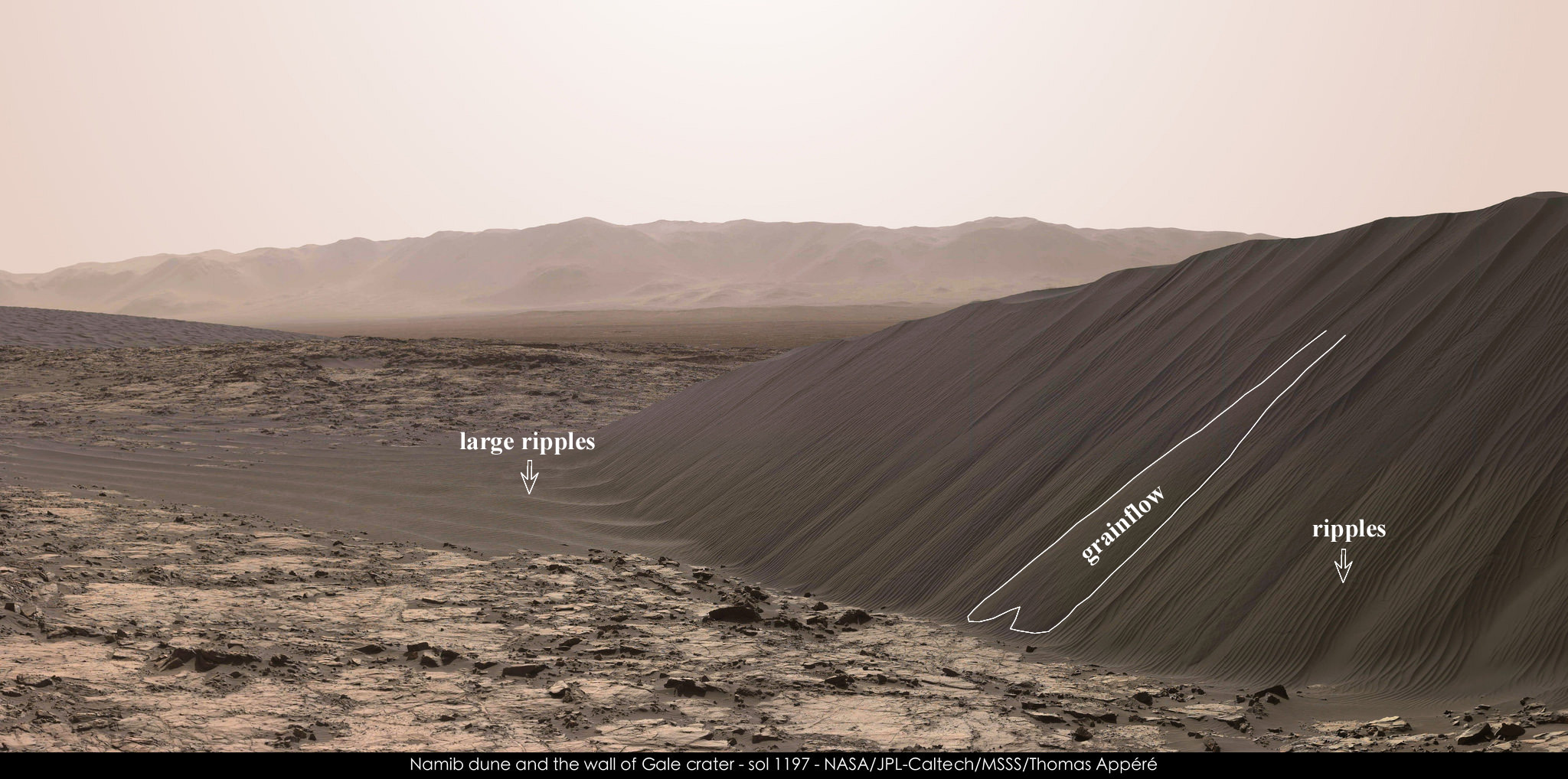
The dunes in this part of the Bagnold Dune Field are slowly marching towards the southwest. Wind blows from the north-northeast and the sand piles up, only to oversteepen on the lee side and form avalanches in what we call a slip face. This happens over and over as the dune moves: saltating sand flies over the dune crest and settles on the upper slip face (what we call grainfall). When enough sand piles up, it oversteepends, and eventually there’s a slope failure: stuff higher up moves down, like a little landslide (what we call grainflow). We see grainflows most commonly when the wind is blowing nearly directly across the crest of the dune.
But when is nature ever so uniform? Sometimes people ask me how strong the wind blows on Mars, as if I could just give them a single value that would apply to all of Mars (its mountains, polar caps, steep crater rims, and flat plains) at all times (its CO2-covered winters, convectively-turbulent summer days, regions prone to seasonal dust storms, and nighttime low-lying flows). Go outside on Earth for a moment and tell me if you can feel the wind moving from different directions, at different speeds, and do it again in 12 hours and again in 6 months. In most places you won’t get the same result, and it is the same on Mars.
You don’t get the same winds blowing here in the Bagnold Dune Field either, even though the dunes are telling us that the strong winds mostly blow from the north-northeast. What can the slip face tell us about that? Let’s have a look:
What an awesome view! Here’s another view of the whole slip face:
It’s totally different from the other side of the dune, which is covered in ~2 m sized ripples that are themselves covered in smaller ripples. Instead, this looks like a giant wall of sand, textured with features that all look like they’ve moved downhill. The smoother surfaces are probably the newest: these are fresh grainflows. But some of the slip face is covered in small ripples. Here’s what I mean:
What you’re seeing is the interplay of at least two different winds. There’s the main wind that blows over the crest, which forms grainflows, and then a secondary wind that blows in a different direction, forming ripples out of sand from the grainflows. Based on the orientations of other ripples, that secondary wind probably blows from the northwest, which is roughly along the slope of the slip face. That northwesterly wind is responsible for making the large ripples at the base of the slip face – when that wind blows, those large ripples would march towards the camera.
It’s pretty typical for two to three wind directions to dominate all other winds in a region, at least in terms of sand transport. On Earth this usually comes down to seasonal changes in weather patterns: winter storms vs. steady summer winds. Perhaps where you live, most of the weather arrives from one direction, but occasional storms may blow in from another direction. Those winds that blow strongest are most likely to move the most sand. This appears to be the case on Mars as well.
It looks to me like the most recent wind activity has formed grainflows, suggesting that the NNE wind has been more recently active than the ripple-forming wind. However, most of the slip face is covered in small ripples, suggesting that this NW wind was, until recently, the prevailing wind. The ripples weren’t able to fully rewrite the topography of the slip face, as you can see they cover slightly larger undulations that were probably older grain flows – this supports the idea that they are formed by a secondary wind that cannot move enough sand to rewrite the entire dune (if it did then the slipface would point towards the southeast, instead of towards the southwest as it does now). We’re probably seeing a seasonal tradeoff between the NNE and NW winds. I might even cautiously suggest that the grainflow-forming NNE wind is active in the current season (local autumn) and that the ripple-forming NW wind blew in a previous season (perhaps local spring or summer). I’d love to get a shout-out from the REMS folks, if they can pull out any new wind data from their partially-broken anemometer.
Happy solstice everybody, and I hope you have a good holiday.


8 Comments
Incredible image – Thanks for sharing!
On Mars it is Ls = 84º, Mars Year 33 (about 12 sols from northern summer and southern winter solstice on Mars). Where did you get this information?
Awesomely, there is an online tool made by the French that will convert any Earth date into a Mars date: http://www-mars.lmd.jussieu.fr/mars/time/martian_time.html. It calculates Mars Year, Ls, and sol number. It also does a “Martian Month” but I’ve never seen anybody use it.
Dr Fenton, Thanks very much for your response to my question about the mass-wasting on ripples on Namib Dune. Those slides are not the first mass-wasting we’ve seen at Gale. There are hundreds of examples of fresh slides in sand on rocky slopes along the traverse, starting at Cooperstown, and also many older fading slides at the same locations. Some of these were deliberately imaged at The Kimberley but many more have been included in images, as they are very common. My question is: how does this slope activity fit into the overall picture of aeolian processes on Mars? This category of slope wasting, though not taking place on dunes or ripples, appears to be recent and ongoing. Does wind reload these slopes and if so how does the whole cycle work on a slope that isn’t moving across the landscape?
Hi Lori,
I’ve noticed that Bagnold Dune has structures on most of it’s surface, that we’ve been calling ripples, that are apparently mass wasting (sliding, avalanching) from their crests. I mean the ripples a few 10s of cm high not the smaller sand ripples. This avalanching is quite clear on several ripples in several images acquired just before Curi rounded the corner to the big slipface. Is this a surprise? Does this mean that now we should stop calling these structures ripples and start calling them dunes?
Yes, those slumps certainly do look like the sort of avalanches that form on dune slip faces. So this is a good question. It’s been noticed, believe me. It’s not the slip face alone that makes the dune, but rather the source of the instability that leads to sand piling up (see here for more: http://www.planetary.org/blogs/guest-blogs/2014/0219-sand-waves-in-the-desert.html). On Earth the instability that causes dunes to pile up makes them big enough that saltating sand that flies over the dune crest can land at the top of the slip face and pile up there, where it eventually oversteepens and then avalanches. Whereas the instability that causes ripples to pile up actually protects the lee side (what would become a slip face if avalanching occurred).
So yes, something interesting is happening here and I don’t yet know what. Forming an avalanche usually happens because either material is added near the top, causing oversteepening (as in the case of a dune) or material is taken away at the bottom, causing overhang. (You could also weaken the material by, for example, having water flow through it, but that’s unlikely here.) So the first thing to figure out is what triggers the mass wasing: added material at the top, or removal from below? Most likely it’s added material at the top. But where does it come from? Saltation path lengths are pretty big on Mars, and the sand comes down to the ground with a lot of momentum. A lot of sand is splashed up, and those splashed grains move (“reptate”) with path lengths not all that different from saltation path lengths on Earth. So maybe these ripples are some sort of hybrid between ripples and dunes: maybe the same instability that leads to ripple accumulation is at work here, but the mechanics of saltation are different in the thin martian air, so that the lee side of the ripple isn’t perfectly shadowed from reptating grains the way it is on Earth. That’s one idea.
Clearly there’s some interesting work to be done here. I’ve thought for a while that these 2 to 4 meter wavelength ripples couldn’t just be analogous to ordinary sand ripples on Earth, and now we’re seeing some nice hints that this may well be the case.
1. How far away is that crater wall and how high is it?
2. Although wind of Martian storms may have considerable velocity, would the Martian atmosphere have enough density or impact to blow a human on the surface as far as was depicted in “The Martian” movie?
1. The crater wall is about 30 km away and it’s about 2 km higher than where the rover currently is.
2. Nope. There might be a few spots on Mars where the wind gets that strong, but that’s pretty rare. You’d know to avoid those locations (like the steep slopes of the big volcanoes, where nighttime slope winds can come screaming down). Dust storms can move around sand and dust, but it wouldn’t be hard to walk in them. Remember how he was almost buried by a sand drift? On Mars a feature like that would take years to move that far. It wouldn’t happen in a single night like that. Which is a pity, because if the winds were really a force to be reckoned with, then it would be much easier to fund a sonic anemometer, which the aeolian and atmospheric community have been trying to make happen for decades. Andy Weir did a pretty good job of getting the science right, but there are places where reality became somewhat exaggerated. Still, it’s a good book/movie.